Introduction
America’s national parks and monuments protect some of our most treasured and irreplaceable cultural resources. They preserve our collective history, which, on the North American continent, stretches back thousands of years, and provide us with a chance to apply the lessons of the past to the present. Our national parks and monuments also include the ancestral homelands for scores of Tribal nations, many of which remain strongly connected to sacred sites and cultural landscapes that are found in today’s parks and monuments.
To honor and protect our diverse and shared heritage, America’s national parks and monuments must be preserved and protected to the maximum extent possible. But the presence of oil and gas development on their doorstep is a stark threat to their long-term protection. Development can destroy archaeological sites and turn sacred spaces and cultural landscapes that tell the story of modern-day Tribes into industrial zones. Like so many extractive activities, oil and gas development also disproportionately impacts communities of color, including Tribal communities that are close to national parks and monuments.
This threat to our cultural legacy came to a head during the Trump administration, which focused on achieving “energy dominance”1 Exec. Order 13783, 82 Fed. Reg. 16,093 (March. 31, 2017). and enacting “industry-first” policies. These policies eliminated important safeguards designed to ensure cautious and well-managed oil and gas leasing and development and led directly to several leasing proposals in close proximity to several national parks and monuments, including Chaco Canyon2BLM, February 2019 Competitive Oil and Gas Lease Sale EA for March 2019 Sale, available at https://eplanning.blm.gov/public_projects/nepa/115496/166245/202599/Farmington_Field_ Office_March_2019_OG_Lease_Sale_EA.pdf. and Hovenweep3BLM, May 2018 Competitive Oil and Gas Lease Sale EA for March 2018 Sale, available at https://eplanning.blm.gov/public_projects/nepa/82261/144833/178528/2018-05-14_- _FY18_CCDO_Leasing_EA_FINAL.pdf., both of which have long-standing importance to many Tribal communities. But this threat did not originate with the Trump administration; the Bureau of Land Management (BLM) has traditionally defaulted to opening public lands to oil and gas development, including lands surrounding national parks and monuments.
But there is hope that our national parks and monuments will finally receive the protection they need and deserve, as the Biden administration has promised to reform the federal oil and gas program. Through this effort, the administration has an historic opportunity to uphold its commitment to protecting the ancestral homelands and sacred sites of Tribes under Executive Order 13985 and other legal authorities. This EO calls for the Federal government to advance racial equity and support for underserved communities4Exec. Order 13985, 86 Fed. Reg. 7,009 (Jan. 25, 2021). BLM, February 2020 Farmington Mancos-Gallup Draft Resource Management Plan and Environmental Impact Statement Volume 1, available at https://eplanning.blm.gov/public_projects/lup/68107/20013477/250018467/FMG_DraftRMP A-EIS_Vol-1_508.pdf., which the Biden administration can do by protecting the relationship Tribes have with many national parks and monuments, as these places continue to provide resources, identity, and spiritual wholeness for many Tribes and Tribal members.
This report looks at five national parks and monuments that honor the culture and history of Tribal communities and examines how oil and gas activities on surrounding lands has harmed and continues to threaten these extremely sensitive and important spaces. This report also offers recommendations on how the Biden administration, through its ongoing review of the federal oil and gas program, and Congress can adopt new rules and policies that provide lasting protection to national parks and monuments.
Federal Oil & Gas Leases and Wells Surrounding Dinosaur National Monument, Hovenweep National Monument, Mesa Verde National Park, and Chaco Canyon National Historical Park in the Four Corners Region

Map depicting Dinosaur National Monument, Hovenweep National Monument, Mesa Verde National Park, and Chaco Culture National Historical Park. Federal oil and gas well sites (shown as red point features) and authorized federal oil and gas leases (shown as black outlined polygon features) are also displayed, demonstrating the concentration of oil and gas leasing and development on federal public lands throughout the greater Four Corners region. Federal oil and gas well sites overlap the majority of authorized federal oil and gas leases, indicating the extent to which existing leases have already been developed.
Federal Oil & Gas Leases and Wells Surrounding Theodore Roosevelt National Park, North Dakota
![]()
Map depicting Theodore Roosevelt National Park in western North Dakota. Federal oil and gas well sites (shown as red point features) and authorized federal oil and gas leases (shown as black outlined polygon features) are also displayed, demonstrating the concentration of oil and gas leasing and development on federal public lands throughout the western region of North Dakota. Federal oil and gas well sites overlap many authorized federal oil and gas leases, indicating the extent to which existing leases have already been developed.
Threatened National Parks and Monuments
Chaco Culture National Historical Park
 Chaco Canyon was once the center of a thriving ancient society whose descendants are members of modern-day Pueblos and Tribes in New Mexico and Arizona. Today, Chaco Culture National Historical Park (CCNHP) continues to be an important, living place for Tribes, and the Park preserves sacred spaces of the ancestral Puebloan and Navajo peoples. This focus on preservation, in turn, ensures that the Pueblos, Navajos, and other Tribes can continue to honor and celebrate the legacy of their ancestors.
Between the years of 850 and 1250 CE, the Chacoan people built huge stone buildings (called great houses) with multiple stories and hundreds of rooms. They used unique masonry techniques and construction in these buildings over many centuries. The size and scope of the structures were planned from the start, rather than taking the traditional path of adding additional rooms as needed. Although each structure was unique, they all shared architectural features that make them recognizable as Chacoan.
The great houses were often oriented to solar, lunar, and cardinal directions while lines of sight between them allowed for communication. Sophisticated astronomical markers, communication features, water control devices, and earthen mounds surrounded the buildings. Furthermore, great houses in Chaco Canyon were connected by roads to other great houses throughout the region.
By 1050, Chaco had an incredible influence over the area, becoming the center of life in the San Juan Basin. It was a place where peoples, families, and societies converged to share their ceremonies, traditions, and knowledge. But by the middle 1100s, Chaco was changing, and many of the inhabitants migrated to new areas.
Hundreds of years later, in 1823, New Mexican governor José Antonio Vizcarra conducted what we recognize today as the first documented Euroamerican visit to Chaco Canyon. While the U.S. Army surveyed the site later, in 1849, Chaco’s remote location ensured a lack of real, more scientific attention until archaeological excavations began in the late 1800s. Using the newfound authority of the Antiquities Act of 1906, on March 11, 1907, President Theodore Roosevelt designated Chaco Canyon as a national monument, and it became a national park in 1980.
Chaco Culture National Historical Park (CCNHP) and several sites in the surrounding landscape are also a UNESCO World Heritage Site (WHS) — the only such site where the underlying mineral estate is under BLM’s jurisdiction. The Park has approximately 4,000 prehistoric and historic archaeological sites, representing more than 12,000 years of human cultural history in Chaco Canyon. In addition, the park contains relatively undisturbed examples of plant and animal communities within the Colorado Plateau ecosystem and offers unmatched opportunities to conserve the region’s biodiversity and monitor its environmental quality. It was named an International Dark Sky Park in 2013.
The great houses, surrounded by sacred mountains, mesas, and shrines, still have deep spiritual, cultural, psychological, emotional, and heritage meaning for the descendants of the ancestral Pueblos and Navajo residents. The national park protects and appropriately manages the remains of many of these incredible structures and is one of the largest collections of ancestral sites north of Mexico. However, there are thousands of Chacoan sites across the modern Four Corners states, including scores of great houses, agricultural sites, small houses, and Chacoan roads that are not within the park and, for this reason, are not adequately protected from potentially destructive development activities. The Greater Chaco Landscape, as the area beyond the Park’s boundaries is known, is under threat from oil and gas leasing, as described in the following pages.

Threats to Resources

The Greater Chaco Landscape is an area rich in cultural resources — but it is also an area that is rich in fossil fuels. Over the years, BLM’s Farmington Field Office has leased nearly 92 percent of the public land surrounding CCNHP to the oil and gas industry, and a draft management plan released by the Trump administration in 2020 would have opened the entire landscape around the Park to further leasing and development5BLM, February 2020 Farmington Mancos-Gallup 2020 Affected Environmental Supplemental Report, available at https://eplanning.blm.gov/public_projects/lup/68107/20013479/250018469/FMG_SuppRpt_A ffectedEnvir_508.pdf.. Meanwhile, oil and gas companies have drilled over 37,000 wells in the area6 BLM, March 2015 Mancos-Gallup Resource Management Plan Amendment and Environmental Impact Statement Assessment of the Management Situation, available at https://eplanning.blm.gov/public_projects/lup/68107/86638/103809/FMG_FinalAMS_201503 17_508_reduced.pdf. and helped build a sprawling network of roads (15,000 miles) that is five times greater than the distance from Los Angeles to New York.7Van Dyke, R., Lekson, S., Heitman, C., & Thomas, J., 2016. ”Chaco Landscapes: Data, Theory, and Management.” Anthropology Faculty Publications, 123, available at https://digitalcommons.unl.edu/cgi/viewcontent.cgi? article=1123&context=anthropologyfacpub
Decades of intensive development have caused profound harm to cultural values in the landscape surrounding CCNHP, as oil and gas wells, roads, pipelines, and other infrastructure have destroyed long stretches of the Great North Road8Van Dyke, Ruth M., 2017. “Impacts of Oil and Gas Drilling on Viewscapes and Soundscapes at the Chaco Outlier of Pierre’s, San Juan County, New Mexico,” available at https://www.archaeologysouthwest.org/wp-content/uploads/Pierres-Viewscape- Soundscape-Report-Van-Dyke.pdf. and transformed Pierre’s Site and other significant places into industrial parks.9 BLM, New Mexico Oil and Gas Lease Sale Parcels, available at https://blmegis. maps.arcgis.com/apps/webappviewer/index.html? id=8aa087e3d43048ba842e00a106ff7061. Further, the incredible dark skies at CCNHP are marred by gas flares, thrown up by oil wells, that light up the sky, as drilling activities are visible for at least twenty miles from the boundaries of the Park. These ongoing oil and gas activities are also a threat to the health and safety of Tribal members who live in the landscape surrounding CCNHP.

The pressure to lease even more federal land to oil and gas companies only intensified during the previous administration. On three separate occasions, the Trump administration tried to sell leases within a short distance of the park10 Reed, Paul F., September 2020. “An Archaeological Reconnaissance of Chaco’s 10-Mile Zone of Protection,” available at https://www.archaeologysouthwest.org/wpcontent/ uploads/An_Archaeological_Reconnaissance_of_Chaco-__Exec_Summary.pdf. The area around the park contains more than 4,200 identified cultural resources, including several that are part of the Chaco Culture WHS, and is one of the last unleased aggregations of federal land in all of northwestern New Mexico11BLM, 2 March 2018 Press Release: BLM Defers Oil and Gas Lease Sale in New Mexico, available at https://www.blm.gov/press-release/blm-defers-oil-and-gas-lease-sale-parcelsnew- mexico.. And each time, the administration backed down after Pueblo and Tribal leaders raised concerns.12BLM, 8 February 2019 Press Release: BLM New Mexico Defers Nine Parcels for March Lease Sale, available athttps://www.blm.gov/press-release/blm-new-mexico-defers-nine-parcelsmarch- lease-sale.13APCG, 23 May 2020 Press Release: All Pueblo Council of Governors Applauds Extension of Comment Period on Draft Resource Management Plan Amendment for Sacred Greater Chaco Region, available at https://www.apcg.org/uncategorized/all-pueblo-council-ofgovernors- applauds-extension-of-comment-period-on-draft-resource-management-planamendment- for-sacred-greater-chaco-region/
Still, this imminent threat remains, as nearly all of the federal land surrounding the park is currently available for leasing and development. The All Pueblo Council of Governors (APCG) has repeatedly called on the federal government to provide greater protections for the Greater Chaco Landscape and, in particular, the lands that are within roughly ten miles of the park. According to APCG, “[t]he Greater Chaco Region . . . centuries ago was the center of a thriving civilization that flourished in the Four Corners region. This society left behind a vast and sacred landscape rich in cultural resources, which the Pueblos use today as integral to individual and collective living identity. Many of these cultural resources are located within 10 miles of the Park.” The BLM is currently in the process of withdrawing federal land in this zone from oil-gas leasing for 20 years. This action is supported by the Pueblos, along with many other stakeholders, who for years have prioritized protecting federal land in this area from new oil and gas development14Governor Vallo, Virtual Film Screening & Panel Discussion: “The Mystery of Chaco Canyon,” available at https://youtu.be/Anr6IA3CBm4..
 Governor Brian Vallo of the Pueblo of Acoma has said about the Greater Chaco Landscape and the ongoing work to protect it,
“There are many generations of Acoma people and Pueblo people yet to come. And so, they have – and should have – the privilege of having and maintaining the connections to Chaco. Even today, we as Acoma people, through our prayer, our song, and pilgrimage, return to Chaco. There are places on that landscape, beyond the park proper, that are critical and crucial components to our own survival and the continuance of our culture.”
Going on to discuss the crisis caused by the oil and gas industry, one that threatens the landscape, the air, the wildlife, and public health, Governor Vallo said,
“America’s Cultural Legacy At-Risk. The remedy is a commitment by those federal agencies and others to consult and reach out to tribes. To help understand that landscape and help them understand more about our contemporary culture that has ties to places like Chaco Canyon.”15Burgh, Robert F. & Scoggin, Charles R. 1948. The Archaeology of Castle Park, Dinosaur National Monument. University of Colorado Studies, Series in Anthropology No. 2. University of Colorado Press, Boulder, Colorado.
 “To continue to permit oil and gas development within this sacred cultural landscape of Greater Chaco will be a direct and unequivocal statement by the federal government that Acoma, Zuni, and the other Tribal concerns, values, culture and heritage associations can and will continue to be neglected and marginalized – and Native Peoples alienated and cleansed from this landscape – in favor of oil and gas companies, which already control so much of the federal land in northwestern New Mexico.”
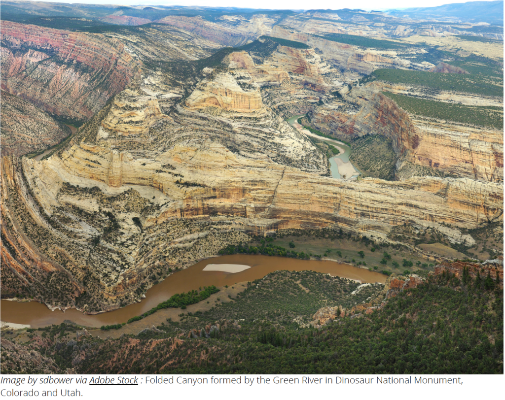
Dinosaur National Monument
Dinosaur National Monument, located on the border of Utah and Colorado, is well-known for its exceptional history of human habitation dating back over 10,000 years, as well as its outstanding dinosaur fossil quarry and scenic river canyons.
Established by President Woodrow Wilson using the Antiquities Act in 1915, Dinosaur National Monument was originally intended to protect 80 acres around an extraordinary fossil deposit located solely in Utah. Then, in 1938, the Monument was expanded to over 200,000 acres to include the Yampa and Green River canyons and an extraordinary surrounding landscape of deserts and mountains.
Those who visit Dinosaur National Monument today are hardly the first. Evidence of human habitation and use in the monument dates back thousands of years, but a considerable number of cultural sites within the monument are related to the Fremont People, who occupied the area from 200 to 1300 CE. While the Fremont people have generally been characterized as a semi-sedentary society that lived in small bands or family groups with the ability to move according to the availability of water and food, we know from early excavations in Dinosaur National Monument that the social complexity of the Fremont was much more multifaceted and nuanced.
Early settlers in what would become Dinosaur National Monument encountered cultural remnants of the Fremont and recognized their significance. In 1939, Charlie Mantle allowed the University of Colorado to conduct a survey of Mantle’s Cave, excavating breathtaking items that illuminate a stunningly complex and rich culture, like an exquisite flicker feather headdress composed of 370 central tail feathers from the red-shafted flicker; a basket containing a set of delicate, finely crafted fishing hooks made of bone and wood set with pine pitch on a three-meter cord; a 28-foot-long necklace of bird bones and juniper berries; and a deer scalp headdress with quills woven through the ears to keep them erect16Perry, Cody M., 29 April 2021. “Dinosaur National Monument should be protected from oil drilling.“ The Salt Lake Tribune, available at https://www.sltrib.com/opinion/commentary/2021/04/29/cody-m-perry-dinosaur/. The cave was not a residential site but rather for storage and items of special significance.

Today, traces of the Fremont can be found on petroglyphs and pictographs in Dinosaur National Monument as a vivid reminder of their lives. The Fremont society were the forerunners of Tribes, such as the Ute and Shoshone, who still inhabit communities in the area today. Moreover, the Zuni people see the Fremont culture as the material evidence of Zuni ancestors who left evidence of their migrations to find the Middle Place, which is the location of the current Zuni village. Any harm to sacred sites and other cultural resources within the monument results in emotional and psychological trauma for the Zuni religious leaders and their community.
In total, 36 distinct Tribes and Pueblos have long established traditional associations with Dinosaur National Monument, but more recent newcomers like Spanish explorers, fur trappers and traders, French adventurers, settlers and homesteaders also passed through this landscape, often leaving traces that can still be seen within the boundaries of the national monument and surrounding landscape.
Dinosaur National Monument (Dinosaur) has long been threatened by oil and gas development near the park. Tens of thousands of oil and gas wells have been sunk here over the last century, with most of them densely packed 30 miles away from Dinosaur National Monument17Utah Department of Natural Resources Division of Oil, Gas and Mining, Well Information Search Overview, available at https://oilgas.ogm.utah.gov/oilgasweb/live-data-search/ldswell/ well-main.xhtml.18NPS, Dinosaur National Monument, Stargazing, available at https://www.nps.gov/dino/planyourvisit/stargazing.htm..
One of the challenges at Dinosaur National Monument is the sheer scope of potential archaeological sites that are at risk from oil and gas development. There are 629 known sites within the monument, but as of 2015, only 10 percent of those sites have had an intensive inventory and field inspection done, known as a class three survey. In addition, very little of the BLM lands surrounding Dinosaur have had the benefit of a thorough professional field inspection.
Oil and gas development near the monument has the potential to disrupt sensitive cultural landscapes that span the monument’s boundaries and include surrounding public lands managed by BLM. Infrastructure associated with oil and gas drilling also threatens scenic views near Dinosaur, and truck traffic is a danger to wildlife and their critical habitat. Natural gas flares could compromise the night skies over “one of the darkest places remaining in the United States… where you can see the stars of the Milky Way galaxy with startling clarity19BLM, January 2018 Competitive Oil and Gas Lease Sale EA for December 2017 Sale, available at https://eplanning.blm.gov/public_projects/nepa/80165/130450/158729/Final_Vernal_EA.pdf.”
Since at least the early 1980s, BLM has regularly offered leases on the monument’s doorstep20Ibid.. Monument advocates have consistently opposed those offerings, out of concern for potential impacts on the monument’s cultural, natural, and scenic values21BLM, August 2015 White River Field Office Record of Decision and Approved Resource Management Plan Amendment For Oil and Gas Development, available at https://eplanning.blm.gov/public_projects/lup/65266/79043/91308/2015_Oil_and_Gas_Devel opment_RMPA_ROD.pdf. But BLM has continued to open sensitive lands around the monument to leasing, although a new planning approach developed for public lands surrounding the Colorado-side of the monument in 2015 does provide some measure of protection against oil and gas drilling22BLM, September 2019 Federal Pipeline Unit Wells 4-21-4-23 and 5-21-4-23 for May 2021, available at https://eplanning.blm.gov/public_projects/74448/200163302/20039932/250046127/Final- Draft-Comment-EA-Appendicies.pdf.
The consequences of opening sensitive lands around Dinosaur to development emerged in the first half of 2021. A new drilling proposal in Utah would allow oil and gas development within a half-mile of Dinosaur and involve the construction and installation of new well pads, roads, pipelines and the drilling of two wells23SUWA, 8 October 2021 Press Release: Southern Utah Wilderness Alliance Supporters, Utahns Gather to Support National Monuments Restoration, available at https://suwa.org/category/press-releases/. If permitted, this development would destroy this remote area’s scenic qualities and could impair cultural values within the monument.
“Drilling and road blasting about a quarter of a mile from Dinosaur National Monument would damage the views, quiet and dark night skies in a remote part of the park and pollute the park’s air and water. This is a zombie lease from almost two decades ago that should never have been allowed in the first place and an urgent reminder of why our national oil and gas program needs immediate reforms.24NPS, Hovenweep National Monument, Hovenweep Site Map, available at https://www.nps.gov/hove/planyourvisit/placestogo.htm” – Cory MacNulty, Southwest associate director at the National Parks Conservation Association (NPCA)
Hovenweep National Monument

Hovenweep National Monument protects the remains of ancestral Puebloan villages. Situated along the Utah-Colorado border between Bears Ears and Canyons of the Ancients national monuments, there are numerous archeological sites spread over a large area of mesa tops and canyons, including six ancestral Puebloan villages25NPS, Hovenweep National Monument, History & Culture, available at https://www.nps.gov/hove/learn/historyculture/index.htm. This area is also the ancestral, sacred, and traditional lands of the Hopi, Zuni, Rio Grande Pueblos, Ute, Diné (Navajo), Paiute, and other Indigenous people. These “Lands Between,” as the area is oftentimes called, are an integral part of a larger, contiguous cultural landscape that connects Chaco Canyon, Mesa Verde, Bears Ears, and beyond26 Ibid..
The first humans to inhabit the area were nomadic Paleoindians, who visited 12,000 years ago to hunt and gather food. Gradually, people began to settle in the region year-round. These ancestral Puebloans were a sedentary farming culture who inhabited the area from a few centuries BCE until about 1300 CE. By the late 1200s, the Hovenweep area was home to over 2,500 people27 Ibid.. There are several towers and structures at Hovenweep that are still standing after 700 years. They represent a variety of shapes and sizes, and the masonry work is skillful and beautiful. The style of the architecture and masonry — in addition to pottery styles — suggest that the inhabitants of Hovenweep were closely associated with groups living at Mesa Verde and other nearby sites, contributing to the idea that landscapes in this area are all connected.

In addition to the towers and kivas (round, semi-subterranean structures used as spaces for religious purposes or other large gatherings) built at Hovenweep, the ancestral Puebloans prepared their land for cultivation. They created terraces on hillsides, formed catch basins to hold storm run-off, and built check dams to retain topsoil that would otherwise wash away. Storage granaries under the canyon rims protected harvests of corn, beans, and squash for later use.
While many of the historical details will remain unknown, a combination of social and environmental factors led the inhabitants of Hovenweep to leave the area near the end of the 1200s. These ancestral Puebloans migrated to areas west, south, and southeast, such as the Rio Grande Valley in New Mexico and the Little Colorado River Basin in Arizona. The Pueblo people of today (including Acoma, Hopi, Zuni, Santa Clara, Taos, Zia, and others) are the descendants of these ancient Pueblo people.
In the mid-1800s, W.D. Huntington, leader of a Mormon expedition into southeast Utah, stumbled across the remains of the Puebloan-era structures. The name “Hovenweep” (a Paiute/Ute word meaning “Deserted Valley”)28NPS, Hovenweep National Monument, History & Culture, available at https://www.nps.gov/hove/learn/historyculture/index.htm was adopted in 1874. In the early 1900s, J.W. Fewkes of the Smithsonian Institution surveyed the area and recommended the structures be protected. And, using his authority under the Antiquities Act, on March 2, 1923, President Warren G. Harding proclaimed Hovenweep a unit of the National Park System.
In addition to its historical and cultural significance, Hovenweep National Monument is home to more than 150 animal species and an incredible geologic landscape29Ibid.. The national monument also has some of the darkest skies in the country. Its remote location, surrounded by the Navajo Reservation and public lands, preserves a dark sky that is largely unaltered by modernity. Hovenweep was certified an International Dark Sky Park in 2014.
Threats to Resources
The landscape surrounding Hovenweep National Monument has been a target for oil and gas development for years. Aging infrastructure from wells that were drilled years ago litter the landscape. According to an analysis by the National Parks Conservation Association and FracTracker Alliance, there are over 140 “orphaned” wells within 30 miles of Hovenweep National Monument30Ibid.. These are wells that have been completely abandoned by their owners — their decaying equipment and deteriorating access roads a blight on this sacred cultural landscape.
Yet, in spite of the increasing number of wells near the monument that aren’t producing any oil or gas, BLM has continued to put parcels near the Monument up for lease — as recently as 2019, when BLM, in spite of receiving formal protests from the All Pueblo Council of Governors and Pueblo of Acoma31NPS, Northern Colorado Plateau Inventory & Monitroing Network, Biophyscial Description of Hovenweep National Monument, available at https://www.nps.gov/hove/learn/nature/animals.htm — leased 30,000 acres of land32NPCA & FracTracker Alliance, Orphaned Wells Near National Parks, available at https://www.arcgis.com/apps/webappviewer/index.html? id=9d1fdef73dbb4950afeb8caa01293071&extent=-18608961.7881%2C1024244.876%2C- 3903700.5385%2C10045037.2061%2C102100. Sales like these are particularly concerning since as little as 2 percent of recently leased land around Hovenweep National Monument has been surveyed for cultural and archaeological sites33 APCG, Letter submitted to the BLM Utah State Office on 17 December 2017, Re: Monticello Field Office March 2019 Oil and Gas Lease Parcels – Scoping Comments, available at https://suwa.org/wp-content/uploads/All-Pueblo-Governors-letter-re-March-2019-leasesale. pdf.
The lands in and around Hovenweep National Monument are connected to a larger landscape of cultural and historical significance. And according to the BLM, there are more than 2,200 known cultural sites within the leased area34BLM, Utah State Office September 9-11, 2019, Oil & Gas Sale Results, available at https://eplanning.blm.gov/public_projects/nepa/121035/20003560/250004198/SalesResults. pdf. Oil and gas development could occur right up to the park’s boundaries, jeopardizing not just the visitor experience but also park resources, including towers and structures that are the remains of ancestral Pueblo villages, not to mention having deleterious and damaging irreversible impacts to the natural and unique environment. Ahjani Yepa, a member of Utah Diné Bikéyah, a Navajo grassroots organization, says,
“When this oil and gas leasing happens on or near sacred lands, it risks de-stabilizing the bedrock (of the structures). Hovenweep is in all of our stories, and to threaten the integrity of these structures jeopardizes everything we’ve carried forward as resilient people.”
In addition, Hovenweep’s internationally recognized dark skies are in jeopardy of light pollution from oil drilling rigs and methane flaring, which can be seen from more than 35 miles away. However, in a positive development, the Biden administration recently canceled many of the recent lease offerings near Hovenweep because of the failure to consult with the Pueblo of Acoma and other Pueblos and Tribes. And many Tribes with connections to the area, including the All Pueblo Council of Governors in New Mexico, the Hopi Tribe, the Ute Mountain Ute, and the Navajo Utah Commission have called for a moratorium on new leasing in the area surrounding Hovenweep National Monument until the full scope of cultural resources is studied and inventoried35BLM, May 2018 Environmental Assessment for March 2018 Competitive Oil and Gas Lease Sale, available at https://eplanning.blm.gov/public_projects/nepa/82261/144833/178528/2018-05-14_- _FY18_CCDO_Leasing_EA_FINAL.pdf.
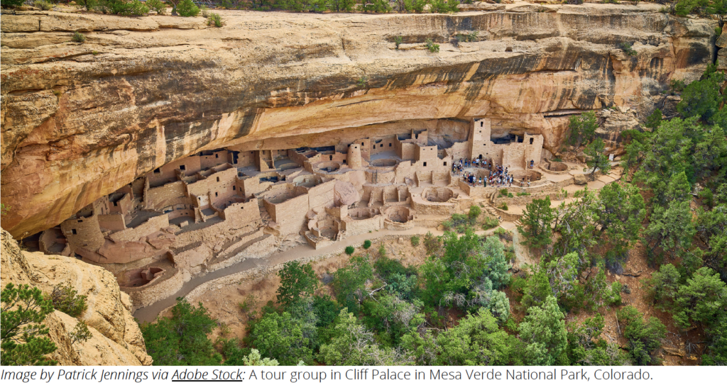
Mesa Verde National Park

Mesa Verde National Park protects nearly 5,000 archeological sites, safeguarding the cultural heritage of many Tribes and offering visitors to Southwestern Colorado a remarkable window into the past. For over 700 years, the ancestral Pueblo people built communities on the mesas and in the cliffs of Mesa Verde. Their ancestors are found throughout the Four Corners area today, as 26 modern Pueblos and Tribes maintain a special relationship with Mesa Verde National Park, including the 19 Pueblos of New Mexico and tribes in Arizona, Colorado, New Mexico, Texas, and Utah36NPCA, January 2021 The Lands Between Fact Sheet, available at https://www.npca.org/issues/responsible-energy..
Ancient peoples lived and traveled through Mesa Verde for many thousands of years. By about 500 CE, ancestral Puebloans settled in the area. Farming replaced hunting and gathering and a settled lifestyle was in place during this early period. By 1000, the people of Mesa Verde were constructing amazing stone masonry buildings. After about 1225, these growing and shifting populations used nature to their advantage, building their pueblo dwellings beneath the overhanging cliffs.
The ancestral Pueblo people were farmers who used the fertile soil on the mesa tops for their crops. They supplemented their farming by gathering wild plants and hunting deer and small game. They lived in the alcoves of the cliffs, in structures ranging from one-room storage units to villages of more than 250 rooms. Rooms averaged about six feet by eight feet, space enough for two or three people. Rooms in the rear and on the upper levels were generally used for storing crops. Underground kivas, or ceremonial chambers, were built in front of the rooms.
By the late 1200s, the population had begun to migrate into present-day New Mexico and Arizona, and the daily use of Mesa Verde had ended by 1290. The structures that remain are evidence of a society that accumulated skills and traditions over centuries and passed them on from generation to generation. This Pueblo society achieved accomplishments in community living and the arts that rank among the finest expressions of humanity in North America, and across the world.
On June 29, 1906, using his newfound authority under the Antiquities Act, President Theodore Roosevelt established Mesa Verde National Park to “preserve the works of man.” It was the first archaeological area in the world to be recognized and protected in this way, and the park was established as a World Heritage Site in 1978. It was named an International Dark Sky Park in 2021.

Threats to Resources
The cultural landscape that includes and surrounds Mesa Verde National Park has been at risk from oil and gas development for a long time. Even though BLM has acknowledged that “[o]il and gas development in the vicinity of [Mesa Verde] would adversely affect the historic setting and landscape associated with” the area, it has continued to permit oil and gas activity on public lands that lie in close proximity to the park37NPCA, January 2021 The Lands Between Fact Sheet, available at https://www.npca.org/issues/responsible-energy. For example, in 2013, BLM announced plans to put more than 10,000 acres of public land near Mesa Verde National Park on the table for oil and gas leasing38NPS, The 26 Associated Tribes of Mesa Verde, available at https://www.nps.gov/meve/learn/historyculture/upload/26meve_associated_tribes_508.pdf39BLM, Appendix H Oil and Gas Leasing Stipulations for Tres Rios Field Office Approved Resource Management Plan/Record of Decision, available at https://eplanning.blm.gov/public_projects/lup/65211/78939/91216/Appendix_H_Oil_and_Ga s_Leasing_Stipulations.pdf. And a 2015 BLM management plan for the area envisioned 1,000 new oil and gas wells in the broader planning area surrounding the park40BLM 16 August 2013 Press Release: BLM Colorado State Office Posts List of Proposed Parcels for November Oil and Gas Lease Sale, available at https://www.blm.gov/pressrelease/ blm-colorado-state-office-posts-list-proposed-parcels-november-oil-and-gas-lease-1.
Over the years, Tribes have raised concerns about oil and gas development within the landscape surrounding the park. And they have called on the Interior Department to “work[]with pueblos and tribes to identify no-leasing zones in landscapes with significant cultural value, like the ones that surround Chaco Canyon, Chimney Rock, Bears Ears and Mesa Verde. Within these zones, which should be broad and based on maintaining context, setting, and cultural integrity, the Interior Department must focus on managing for the protection and restoration of cultural values.41Proctor, Cathy. , June 2013. “Feds to re-offer oil and gas leases near Mesa Verde National Park,” Denver Business Journal, available at https://www.bizjournals.com/denver/blog/earth_to_power/2013/06/feds-to-re-offer-landnear- colorados.html” The National Park Service has expressed similar concerns and warned that “[o]il and gas development near the park may impact air resources (specifically mononitrogen oxide emissions), dust, night sky and viewshed, threatened and endangered species, wildlife corridors, water quality, and visitor safety.42BLM, Appendix R Bureau of Land Management Master Leasing Plan Policy and Description of Leasing Analysis for 2015 Tres Rios Field Office Approved Resource Management Plan/Record of Decision, available at https://eplanning.blm.gov/public_projects/lup/65211/78951/91228/Appendix_R_Master_Lea sing_Plan_FINAL.pdf”
Theodore Roosevelt National Park

Long before Theodore Roosevelt first visited North Dakota in the late 1800s, numerous different cultures inhabited the state’s badlands region. Ancient peoples were able to use the ecological diversity and unique geology of the badlands to gather plant materials, procure clays to make paints, find water, and hunt animals. Thus, “today, Theodore Roosevelt National Park is more than simply a natural park with large areas of wilderness; it is a cultural landscape where the value of all of its resources are both natural and cultural.43BLM, Appendix R Bureau of Land Management Master Leasing Plan Policy and Description of Leasing Analysis for 2015 Tres Rios Field Office Approved Resource Management Plan/Record of Decision, available at https://eplanning.blm.gov/public_projects/lup/65211/78951/91228/Appendix_R_Master_Lea sing_Plan_FINAL.pdf”
Archaeological items found in North Dakota’s badlands region suggest that it has been inhabited for thousands of years. And interpretations of ancient cultures by Tribal elders tell us that the surrounding badlands prompted unique adaptations amid the awe-inspiring landforms, which made the site spiritually significant in many ways.
What is now Theodore Roosevelt National Park was once the historical territory of numerous Native peoples — and, at contact, specifically the Three Affiliated Tribes, also called the Mandan, Hidatsa, and Arikara Nation44Reed, Paul F., 2021, “Oil-and-Gas Leasing in the West, 2021,” available at https://www.archaeologysouthwest.org/wp-content/uploads/Oil-and-Gas-Leasing- Paper_Reed-2021.pdf. These Tribes now live on the Fort Berthold Indian Reservation, northeast of the park. Many other Tribes, including the Blackfeet, Gros Ventre, Chippewa, Cree, Sioux, and Rocky Boy45NPS, October 2015 Foundation Document Mesa Verde National Park, Colorado, available at http://npshistory.com/publications/foundation-documents/meve-fd-2015.pdf, came to this area of western North Dakota in the early 1800s for hunting and trading. Each Tribe has a unique history and relationship with the badlands.
Native peoples considered the buttes the homes of many animal spirits. Some found the isolated, steep-sloped bluffs to be excellent vision quest sites. Others came to hunt bison, trap eagles, or collect colored clays used as paints from areas surrounding springs. Theodore Roosevelt National Park is a place of significance for many Indigenous peoples whose association with the land is rooted deeply in the past.
In the wake of personal tragedy, Theodore Roosevelt found solace in the North Dakota badlands. And years later, he channeled that love of the land into policy, setting aside 130 million acres for conservation. This is a familiar story that has unfortunately overshadowed the presence of the Native peoples who have had a connection to this landscape for generations.
In 1935, the area was set aside as the Roosevelt Recreation Demonstration Area, and it was transferred to the U.S. Fish and Wildlife Service as the Theodore Roosevelt National Wildlife Refuge in 1946. In 1947, by Act of Congress, this area was renamed Theodore Roosevelt National Memorial Park and transferred to the National Park Service. In 1978, the park’s designation was changed to Theodore Roosevelt National Park.

Threats to Resources

In western North Dakota, where the national park is located, the Bakken formation contains one of the largest oil deposits in the country. This has brought extensive development to this once-isolated area, which has been detrimental to the cultural landscapes and values within and around the park. Oil and gas development now surrounds Theodore Roosevelt National Park, as nearly 75 percent of the Little Missouri National Grassland, which borders the park on all sides, has already been leased for oil and gas development46NPS, January 2017 Theodore Roosevelt National Park, North Dakota Historic Resource Study, available at http://www.npshistory.com/publications/thro/hrs.pdf.
The national park has traditionally served as an escape from much of the oil and gas development in the region. But the expansive daytime views and dark night skies have been disturbed and severely compromised by infrastructure and flares from nearby operations. For example, a recent study prepared on behalf of the National Park Service documents “the damaging effects of [encroaching oil and gas development] on viewscapes, soundscapes, and air quality. Such resources maintained more abstract qualities that visitors expected in a natural park that represented both a vignette of primitive America and Theodore Roosevelt’s nineteenth-century Badlands experience: the solitude, quiet, and isolation of the prairie, the sense of vast openness, and the experience of a black, starlit night.47Howells, Robert E., 27 August 2020. “Revisiting the tangled legacy of Theodore Roosevelt National Park,” National Geographic, available at https://www.nationalgeographic.com/travel/article/theodore-roosevelt-national-parkexamining- a-complicated-legacy”
Although the park is safe from drilling within its boundaries, the unique make-up of the park makes it vulnerable to impacts from nearby oil and gas development. Theodore Roosevelt National Park is roughly 70,000 acres, split into three separate units. A visitor standing atop a high butte sees a mixture of state, federal, and private land. The cultural landscapes and resources within the park are affected by what happens outside of it48NPS, Theodore Roosevelt National Park, Cultural History, available at https://www.nps.gov/thro/learn/historyculture/cultural-history.htm. In fact, NPS has described development taking place around the park as “widespread, “severe,” and the “most significant parkwide issue.49USDA, Northern Great Plains Management Plans Revision Draft Supplemental Environmental Impact Statement for Oil and Gas Leasing, available at https://www.fs.usda.gov/nfs/11558/www/nepa/92388_FSPLT3_4475264.pdf”
Ultimately, the exploitation of oil and gas resources poses significant ongoing and potential threats to the totality of the faunal and floral communities that have existed in and around the park for millennia. Native populations utilized the landscape resources to maintain a lifeway in a balanced manner without impacting the sum total of resources. While isolated oil and gas wells may not pose an extensive threat, the cumulative combination of thousands of wells provides a higher likelihood of causing irreversible, long-term impacts to the park’s cultural landscapes and resources, along with associated flora and fauna.
“Our national parks are not protected if they become islands in a sea of development – and that is exactly what the three units of Theodore Roosevelt National Park could become without thoughtful planning specific to how and where oil and gas development occurs near the park. Clear, dark night skies that I remember could be replaced by flares and lighting. Some of this development is visible from the park today, but it’s not too late to limit the impact50Motsko, Mark, 28 October 2017. “Op-Ed | Recalling Theodore Roosevelt’s Love Of the Land While Worrying About Oil And Gas Development.” National Parks Traveler, available at https://www.nationalparkstraveler.org/2017/10/op-ed-recalling-theodore-roosevelts-loveland- while-worrying-about-oil-and-gas-development.” – Mark Motsko, former ranger.

Recommendations
National parks and monuments across the country are increasingly under threat from oil and gas development on nearby public lands. Chaco Culture, Theodore Roosevelt, Hovenweep, and other parks and monuments are at-risk of becoming “islands in a sea of development,” as oil and gas infrastructure and drilling activities advance steadily closer to their borders. And their cultural landscapes and values, which are of great importance to many modern-day Tribes, are becoming more and more industrialized and fragmented. But there are steps the Biden administration — and Congress — can take to recognize that our national parks and monuments are frequently the centerpieces of much larger cultural landscapes and to provide those landscapes with enhanced, lasting protection. Such steps include:
1. Protecting public lands surrounding national parks and monuments by closing them to oil and gas leasing:
Through its ongoing review of the federal oil and gas program, the administration should establish new rules and policies that require BLM to formally close to oil and gas leasing public lands surrounding and adjacent to America’s national parks and monuments. Further, Congress should pass legislation, including the Chaco Cultural Heritage Protection Act, to permanently protect sensitive public lands around national parks and monuments.
2. Establishing other protective designations around national parks and monuments, beyond BLM’s “multiple use” mandate:
Through the land use planning process, the Biden administration should identify and pursue opportunities to establish protective designations surrounding national parks and monuments. BLM has broad authority to establish “areas of critical environmental concerns” and other designations as a means of protecting sensitive landscapes that surround national parks and monuments. Such designations, the boundaries of which should be broad and informed by viewshed and soundscape analyses, can act as mechanisms to establish leasing closures and to guide development activities (on existing leases) in a way that better protects cultural landscapes and resources. 3. Developing consultation protocols with Tribes that are affiliated with national parks and monuments: BLM should develop consultation protocols with affiliated Tribes and other key stakeholders, including NPS and state historic preservation offices, concerning the management of public lands surrounding national parks and monuments. Such protocols can demonstrate that BLM, NPS, and affiliated Tribes all possess an interest in the management of public lands around national parks and monuments and identify the procedures that will be followed when development activities are proposed on those lands.
4. Prioritizing public lands surrounding national parks and monuments for restoration:
The Biden administration should prioritize landscapes surrounding national parks and monuments for restoration. The administration can do this by developing targeted restoration initiatives and plans, which can provide a framework for reclaiming abandoned well pads and access roads, removing infrastructure, and, to the extent possible, restoring impaired cultural attributes. Further, the administration should take steps to account for restoration needs during the land use planning and implementation process, including by deferring or deemphasizing development activities in areas that are prioritized for restoration.
It is not sufficient to just protect cliff dwellings at Mesa Verde, badlands at Theodore Roosevelt, towers at Hovenweep, or great houses at Chaco Culture National Historical Park. We must instead recognize that those features are integral components of much broader cultural landscapes that extend well beyond the artificial boundaries of national parks and monuments. And we must do our utmost to safeguard these broader landscapes, which harbor the sacred spaces of the many Indigenous peoples to whom this land represents the past and the present.
About The Coalition to Protect America’s National Parks and Archaeology Southwest
![]()
The Coalition to Protect America’s National Parks represents over 2,300 current, former, and retired employees and volunteers of the National Park Service, with over 40,000 collective years of stewardship of America’s most precious natural and cultural resources. Recognized as the Voices of Experience, the Coalition educates, speaks, and acts for the preservation and protection of the National Park System, and mission-related programs of the National Park Service. More information can be found at protectnps.org.

Archaeology Southwest is a private 501(c)(3) nonprofit organization based in Tucson, Arizona, that explores and protects heritage places while honoring their diverse values. For three decades, Archaeology Southwest has worked to compile archaeological information, make it accessible and understandable, share it with the public and decision-makers, advocate for landscape-scale protection, and steward heritage properties and conservation easements. Learn more at archaeologysouthwest.org.
Acknowledgements
Thank you to the National Parks Conservation Association Southwest Regional Office for the support, feedback, and review provided on this report.
Click here to download the report. (PDF)